May 9, 2013
On the 9-th of May MLAE team has reached the village of Resolut. Happy Victory Day to everybody!
May 1, 2013
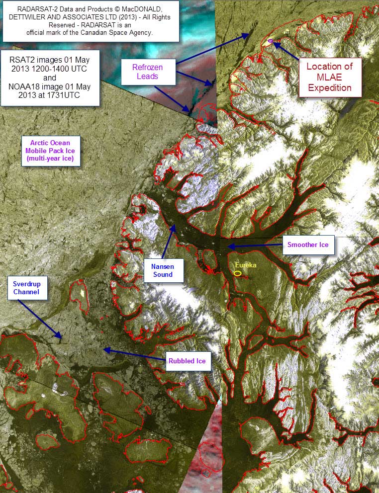
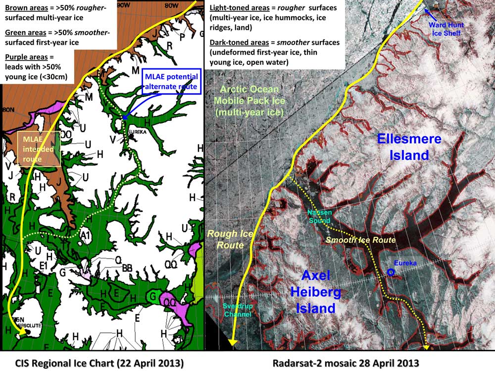
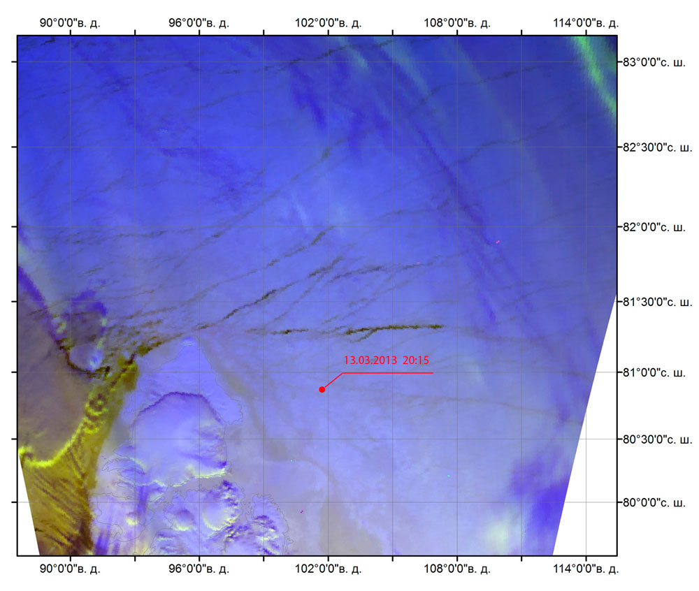
Information and images of narrow fast ice was prepared by: Trudy Wohlleben, Canadian Ice Service, 30 April 2013
RADARSAT-2 data and Product © MacDONALD, DETTWILER AND ASSOCIATIES LTD (2012) - All Rights Reserved - RADARSAT is an official mark of the Canadian Space Agency.
Interpretation of Radarsat Images:
1) Rough surfaces look light-toned or white (e.g. multi-year ice, long linear pressure ridges, hummock fields, land surfaces)
2) Smooth surfaces look dark-toned or black (e.g. open water leads and fractures, thinner new ⁄young ⁄first-year ice in refrozen leads, undeformed first-year land-fast ice in sheltered bays)
Potential for re re-development and widening of a shore lead between the coastal fast ice and the offshore mobile pack ice
Tuesday, 29 April 2013: Currently, there is a marked shear zone in places between the coastal fast ice and the offshore mobile pack ice. Winds in the vicinity of the northeast coast of Ellesmere Island are along-shore, from the northeast.
Wednesday, 01 May 2013: Winds will continue to be along shore (northeasterly). No significant development of an open water lead between the mobile ice and the fast ice is expected. Caution: occasional small open water areas may develop in the lee of sect ions of the coastline ⁄ fast ice that are perpendicular to the winds.
Thursday, 02 May 2013 to Saturday, 04 May 2013: A weak low pressure system will move over the northeast coast of Ellesmere Island from the south, causing winds in the area to become light and variable. No significant development of an open water shore lead is expected
April 30, 2013
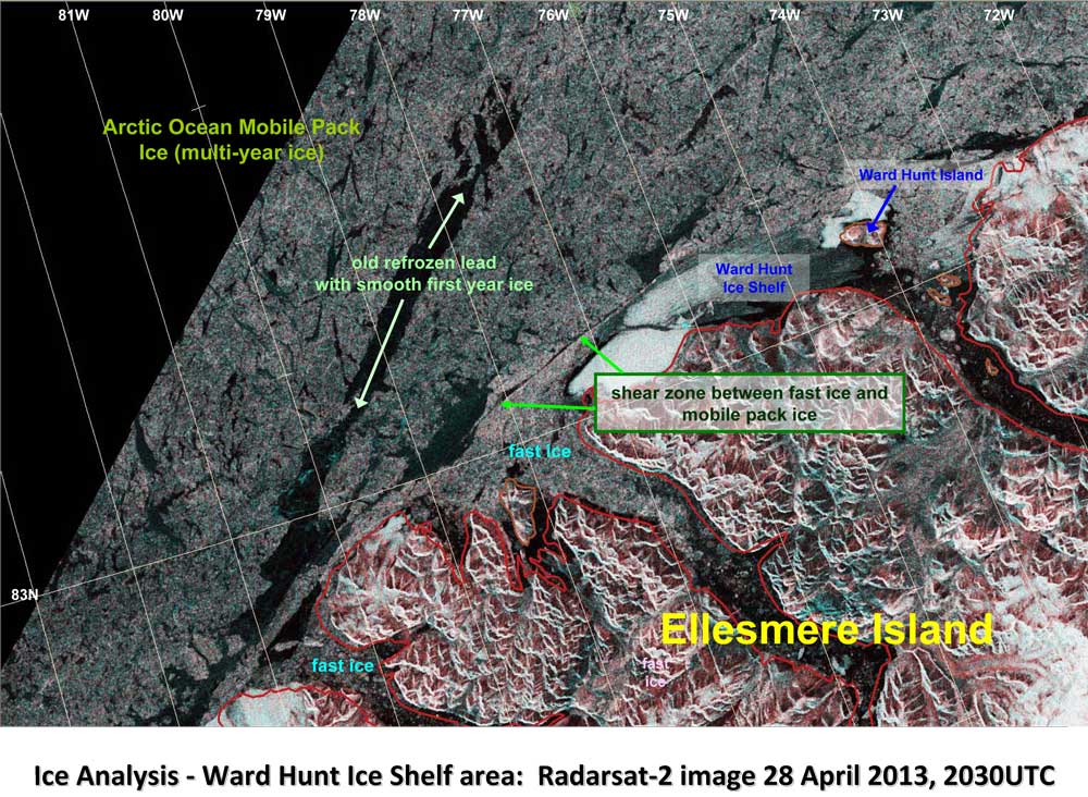
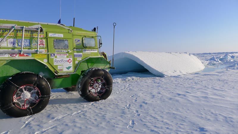
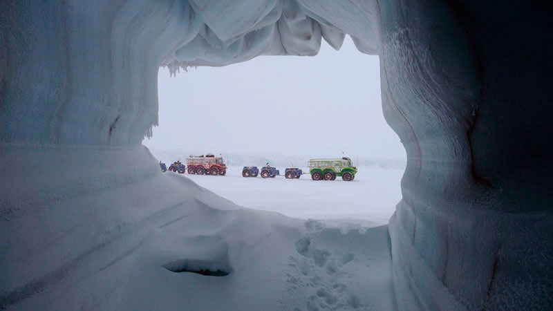
21:21 local time (UTC-4) - MLAE-2013 team broke through high coastal hummocks and drove automobiles Yemelya-4 and Yemelya-3 onto fast ice beside the coast of Ellesmere Island, Canada (27 km Westward from Ward Hunt Island). The Arctic Ocean was left behind. The coordinates of the place where we reached the fast ice are N83°07,928' W075°59,059'. In the morning on the 1-st of May this news was sent to the Canadian representative office of ITAR TASS (the information sponsor of the expedition) and was further spread through its channels. All participants of the expedition are sound, autos are in good condition, the trailers got free from many layers of ice, in barrels there are more than 1000 litres of Diesel fuel left, what must be enough for 1600 km to reach the village of Resolut, the capital of Nunavut Province.
Afanassi
April 24, 2013
Day 55 from start.
N 84° 38' W 074° 44', 599 km from The North Pole.
164 km to Ward Hunt Island.
We are going down and down along the longitude every day. The sun is higher and brighter. But there is still a lot of ice in the frozen desert and no sign of its melting, except snow melting on the surface of our black wheels. The sign of the oncoming of spring is a noticeable smell of sea water from the nearest crack. A few days ago water in fresh cracks would be covered with a thin film of ice immediately, but now when daily temperature is near -20 degrees Celsius, it has more time to evaporate the fumes of the sea. Today it was not windy, so everyone (more or less) took a pleasant bath in the snow, honestly considering this as another sign of spring oncoming.
Afanassi
April 17, 2013
Arctic Ocean, Canadian Sector, N 86° 56' W 071° 12' t-16°C, P 1014 mb, there is no wind and it is sunny. Five days ago a drift division line made us change our course from going straight to the South to the South-East. About 100 km of difficult driving along that line finished yesterday when we finally managed to cross it in its narrowest part. The drift stopped and the ice on the line concentrated well enough allowed us to cross a 70 meter wide strip of crashed and frozen ice balls. We are now on the South side of the drift line and are able to continue driving "Yemelyas" down to the South along the 71-st western meridian aiming at Ward Hunt Island. The distance to the nearest destination is 420 km.
Afanassi
April 12, 2013
Canadian Arctic Sector N 87° 39' W 83° 40'
After two days of such fast going down South from the point of 90 degrees North the expedition stopped in front of one kilometer wide drift division line. We went down and walked among the chaos of huge three meter thick ice blocks before we reached the actual line of division. It was something incredible for all of us we saw for the first time. Moving almost silently at the speed of 4-5 hundred meters per an hour the ice field we were standing on was passing another one. The line between them was precisely straight and, I am sure, miles and miles stretch. I could easily step forth, crossed it and walked on the other side of the line. But how to drive automobiles across it? On each side of that line there were pressure ridges, some of them reached 7-8 meters above the water level. From the Arctic and Antarctic Research Institute we received an infrared satellite image showing ice surface from the North Pole to the coast of Ellesmere Island in a section between the 55-th and 85-th western meridians: yes, there are two very well visible drift division lines on the satellite image and we are near one of them stretched over our way in the direction of 135-140 degrees. What to do now? The right decision must be made now: shall we go East or West?
Afanassi
April 6, 2013
04:30 MOSCOW TIME Geographical North Pole N 90°00,000'
It is the second time in the history of world automotive industry that cars reached the North Pole from the closest land. And again as well as four years ago these cars are "Yemelya" of Vasily Yelagin's design. This time to reach the North Pole from Severnaya Zemlya took 37 days that is only one day less than in 2009. In the MLAE team there are seven people: Vasiliy Elagin, Afanasiy Makovnev, Vladimir Obikhod, Alexey Shkrabkin, Andrey Vankov, Sergey Isayev, Nikolay Kozlov. Today and tomorrow the team will take a rest and also arrange themselves and cars. We have the second not less difficult step before us – to reach the Canadian settlement Resolute 74 degree of north latitude, and we have to do it using fuel that we took on start for the whole route at once.
Afanassi
April 1, 2013
Marine Live-ice Automobile Expedition 2013 Arctic Ocean N 86° 10' E 109° 01' 230 nautical miles to Pole. Today was a very good driving day. We drove 87 km and at the end of the day entered no-night zone. The midnight sun is quite high now above the northern horizon. It allows us to continue driving all night, taking turns sleeping and changing each other behind the steering weel.
Afanassi
March 30, 2013
Marine Live-ice Automobile Expedition 2013 is still in the Arctic Ocean, our coordinates are N 84° 16' E 106° 222'.
There are 640 km left from here to the North Pole and 467 km back to the point where we abandoned the last piece of land - the coast of Severnaya Zemlya Archipelago. Odometer on the GPS navigator is showing 933 km, barometer 1030 mb, temperature -18 °C, weak south wind. The sky is cloudy, but the sun is shining softly through a thin layer of clouds. This light makes no shadows on the snow surface and for the drivers it is not easy to choose the road. Bright headlight led lamp helps enough to make driving possible. The last few days we were able to drive our "Yemelyas" over many flat fields of ice, rarely crossing pressure ridges and so called "rivers". Average daily speed was 5-8 km/hour, while maximum speed sometime was as high as 44 km/hour. "Rivers" are boundaries between two large fields of one year old ice (up to 130-150 cm), drifting parallell to each other. The space between fields can be up to a few hundred meters and it is always covered with a newly formed thin ice (10-20 cm), which in the middle vanishes into 5-6 cm thick young ice or nilas. "Yemelya" can cross such a "river" only speeding up to 30-40 km/hour. Sea ice surface is so flexible, that behind the vehicle a wave is running. The trailers aftewards we pull with long kevlar ropes. They often break through the ice in the middle of such "river", but float and we all make extra efforts to pull them out of water onto thicker ice surface.
Afanassi
March 22, 2013, Sea ice automobile expedition
Today the driving course was mostly 45-50° along the wide ice-hole (glade), in some places it was a few miles wide. We came up to it yesterday, a dense steam was going out – the evidence that the ice has broken not long ago. We are a little late. Yesterday was the first day when her Majesty Arctic gave us a little break. Finally there were ice fields alternated with ice ridges, but it was not a solid area yet, and we slipped about fifty kilometers in half a day. Our short happiness ended with a big ice-hole as usual. But everything is over some time, and it was over too: the ice-hole ended with a spectacular semicircular line of separation and was divided into a bunch of small cracks, it gave us an opportunity to move to its northern shore. We made an overnight stop at the beginning of eleventh – we did not want to be in the zone of shredded ice and active drift.
We got a picture from AARI: we can see where we should go to minimize the number of breaks. Unfortunately we cannot see the degree of ridging in the pictures – because of the resolution. There are more daylight hours and if there is no too strong hummocking, we can go in rotating teams. Subwatchmen can sleep on the way, it is much better to sleep when the vehicle is softly rocking. The weather is strange – the pressure is still very high, but it’s warm, sometimes visibility is a hundred meters or less. At such moments pleasure from driving is more than doubtful, but it will be over, right? There is a little left to reach 82°, and I want to believe that the following message will be sent from there, from this invisible, but important for us boundary.
Overnight point ML130322V 22:12 Krasn.vr.
N 81 ° 47,993 'E 103 ° 41,012'
P 1036,7 mb,
t -30 ° C, wind SW 3 m / s
V. Elagin
N 80° 41,974' E 101° 40,610'
Today is the13-th day of our driving adventure. We are in the sea on a drift-ice about 350 km away from the start point and about 70 km from the nearest coast of Severnaya Zemlya Archipelago which we can still see westward of us as a smooth line of hills and glaciers. On the skyline behind us southward there is a fantastic chain of icebergs, the size of each one is a 10-storied building, it looks like they are trying to scratch the sky, while their bottoms are scraping the sea floor quite well.
Eastward we can see the yellow solar glow surrounding the low sun. And northward over endless pressure ridges, crevaces and polynyas our first goal is laying: The North Pole; it is only 1040x2 km from here (1040 km in a straight line and over 2000 km in reality).
The temperature -35° is very good for us since most of ice polynyas have frozen and turned into a paved road, so we can pick up the speed up to 14-15 km per hour for a while. It sounds weird car-wise, but imagine that each of our Yemelyas have to pull three trailers which weigh in total 2,5 tons. That is why we are driving slowly – an average driving speed is 8,5 km per hour.
Only two polar bears, one seal and an unidentified duck came out to welcome us in the Laptev Sea.
Posted by Afanassi Makovnev.
N80° 14,927’ E097° 27,217’. Machtoviy Island. We arrived at 8 p.m., we are staying here for the second day. According to our plan we will leave tomorrow at 10 o’clock in the morning.
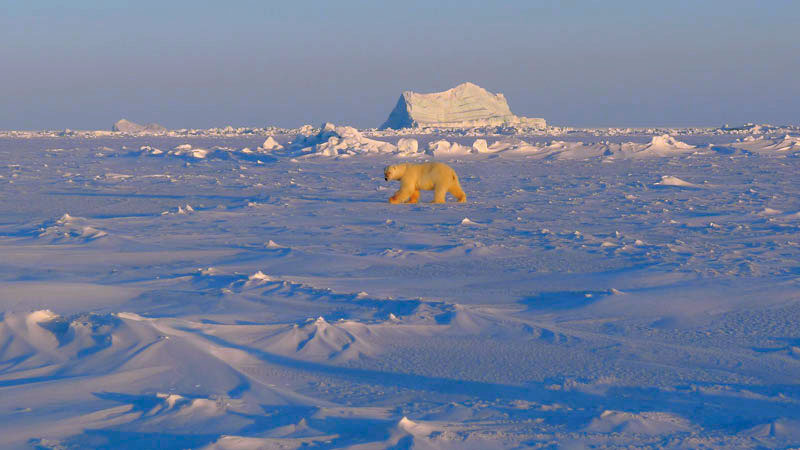
N80° 14,927' E097° 27,217'. Machtoviy Island. We came here escaping from a sharp wind that was hard even for the cars. Here on the south end of the island there is a very nice cliff under which we got saved ourselves from the wind. Tomorrow we are going to our fuel drop of 2009 – there must be something. We will take all the “crumbs”. By the midnight stars appeared in the sky, low drifting snow disappeared and in the morning the weather was shiny and windless. 30 degrees of frost, but when there is no wind it’s much easier to stand it. We went to the drop by a long way round, the islands are seaward. The freezing panorama was open for our eyes: the frozen sea, now it was the Laptev Sea, and icebergs of different shapes and sizes rise from it. We went closer to the one we liked. We walked around, climbed, found a place where a she-bear was picking snow looking for a suitable place for a lair – it’s time to lie and keeping back from vanities of the world to bring forth young. When we were watching the vicinities from above, we notices a he-bear, however he noticed us too. We came closer, about 30 meters; took a lot of pictures and moved to the drop. We took the fuel and returned to the station. Till the end of the day we were preparing for driving on drift-ice. In the evening we received a pleasant message by e-mail from Bichenkov U.D Arctic and Antarctic Research Institute: a long-awaited photo of ice situation. Now the picture is clearer. Time to hit the road!
I will write from this most grifting ice. Greetings to all!
V. Elagin
Saturday, February 23, 2013
We are at Golomyanny Polar Station on Severnaya Zemlya Archipelago ten days already. It is normally -30 degrees Celsius. Daylight hours are not very long. The sun showed up above the horizon only two days ago. It means the end of the polar night. Here we are living in a warm house, eating homemade food, working in a warm garage and in a warm workshop, preparing our two cars "Yemelya-3" and "Yemelya-4" for the long trip across the ice. Panasonic has sponsored me with a new video camera Panasonic AG-AC90. I have to learn a lot about the way it works, as it has many adjustments for a high quality picture and professional sound Dolby 5,1ch.zoom. Now I am sewing a warm coat for the camera, because it has to work at -30 – -40 degrees Celsius. During the first try of filming here at such low temperature I could hardly press the On/Off Manfrotto external button through my gloves, so small the button is. I had to make a wooden addition to that button about 1 inch square, so I will be able to press it with big mittens on my hands. Now one car - green Yemelya-3 is ready, now it has a double insulation layer of foam inside. The red Yemelya-4 is in the garage now. The work is going for more than 12 hours every day. We also need to prepare 6 trailers; each of them will carry 400 liters of Diesel fuel and plastic drums with food and personal staff.
And now a short geography lesson about Severnaya Zemlya Archipelago. This year it is 100 years since it was discovered by s/v "Taymyr" and s/v "Vaigach". Its first name was The Land of Nicolas the Second (the last Russian tsar). It was the last geographical discovery on our planet. It is the biggest polar bear sanctuary in the Arctic. Posted by Afanassi Makovnev.
Wednesday, February 20, 2013
Congratulations!!!
Happy birthday to MLAE-2013 expedition leader Vassily Yelagin!!!
We wish you luck. We wish you to find the right way in the ice fields in the dark polar night and reach the cherished point.
We root for you and your team and believe in the success of the expedition.
Your Friends
Wednesday, February 20, 2013. Severnaya Zemlya, Sredny island.
It does not happen often when you have three holidays in one day. The first one is The Rise of The Sun. We could watch its red glow every day, but today it must have shown us its upper edge above the South horizon at noon. But at the record temperature of -36°C it was cloudy and we did manage to see it. The second holiday is a jubelee - Vasily Elagin is 60 today! This is him who we could see the whole working day (more than 12 hours), in the garage and in the workshop, where we continued to work on green "Yemelya-4". In the evening gathered round the festive board we congratulated the hero of the day on his birthday, wished him in this final year of the decade to achieve all what he sought the latest ten years. After greeting toasts Vasily called his home and told us the news, which appeared to be the third holiday - the Canadian Embassy in Moscow granted visas for us to enter Canada, and this entry we are allowed to do at its northernmost village Resolute Bay.
Posted by Afanassi Makovnev.
Wednesday, February 13, 2013
An early wake up at 5 o'clock allowed us to make a very long charter flight by twin engine Antonov-26 from Vorkuta to Norilsk and then to Sredniy Island of the Severnaya Zemlya Archipealgo. While the plane stood still on the runway of Norilsk airport (Alykell) Father Georgiy, the head of Taymyr eparchy, came on board to give us his blessings. Each of us was also greeted by our old friend and the most loyal expedition supporter Igor Uzdin, the head of NorNikel Transportation Department. Another very good friend of the expedition Victoria Koriukina came from Norilsk, but was not allowed to reach the plane by the airport security, that was a pity, as we brought a gift for her today's birthday. Then right in the plane our foreign passports were stamped and we filled in customs declaration. Russian border was officially crossed. Immediately after that the plane was airborn agin; and three hours later in the polar darkness lit only by the crescent moon, several stars and runway lights we landed on 3000 meter long airstrip of Sredniy Island. Miracles do happen sometimes, and it was one of that sort.
Posted by Afanassi Makovnev.